
Redistricting Commission releases newest Congressional map


SAN LUIS VALLEY — As the deadline for completion rapidly approaches and with more than 30 public hearings held across the state, thousands of comments made online, and numerous drafts created by non-partisan staff members, the newest map for Congressional redistricting in Colorado was released late Friday afternoon, Sept. 3.
The release of the map signals the final phase of the process and is the first of three maps to be released, all based upon 2020 census data recently provided to the commission.
However, the commission could approve this map if eight of the 12 delegates on the commission voted to approve.
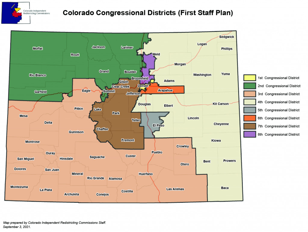
Of primary interest to residents of the San Luis Valley is a reconfigured District 3 which includes the San Luis Valley plus Durango, Eagle and Pitkin counties. The district also contains two relatively large population centers — Mesa County and Pueblo County — and is 26% Hispanic.
In an equally significant change, the reconfigured District 3 would also not have an incumbent as Republican Rep. Lauren Boebert would no longer live inside district boundaries. Instead, she would be one of two incumbents included in a reconfigured District 2 along with Democratic Congressman Joe Neguse of Lafayette.
Even though she does not live in the proposed District 3, she could still run for the office as district residence is not a requirement in a Congressional race.
An initial map divided the San Luis Valley, a proposal that was met with sharp and quick criticism. Another version moved the Valley to the fourth district, which would have extended to the Kansas border and farther north to include Weld County, which concerned several local citizens.
A third map created a southern district that ran the length of Colorado and included both the San Luis Valley and southern counties on the Eastern Plains. However, that map drew criticism at the redistricting hearing in Alamosa as it also contained significant parts of El Paso County. That version did draw enough support to warrant a vote from the commissioners but failed to pass.
Additional evidence of the focus on this part of the state is reflected in a preliminary staff memo composed by the non-partisan staff members who drew the newest map and released it as a separate document.
According to the memo, “At its meeting on Sept. 1, 2021, a majority of the Congressional Commission voted to recommend to non-partisan staff that, due to expressed communities of interest, the following should be kept together in a single congressional district: (1) The six counties of the San Luis Valley; (2) Huerfano, Las Animas, Otero, and Pueblo Counties; and (3) The Southern Ute and Ute Mountain Ute tribal lands in Archuleta, La Plata, and Montezuma Counties.”
The memo goes on to make it clear that it is up to the commission to make the decision.
Although this non-partisan process is the result of the passage of Amendment Y, which received support from the majority of voters, the Colorado Congressional district map had to be redrawn to include an eighth district, the result of census figures that showed an increase in Colorado’s population.
The newest map, along with other versions that have been presented, was drawn by non-partisan staffers and guided by criteria laid out in the amendment, including the protection of minority group voting, geographically connected borders, preservation of communities of interest, political competitiveness and fair and effective representation of constituents using politically neutral criteria.